What are the project features of the Bar Mills hydro project?
The Bar Mills dam (FERC No. 2194) is a 4MW facility constructed in 1956 located on the Saco River immediately downstream of the West Buxton Dam and upstream of the Skelton project dam. The project consists of a dam structure, powerhouse, boat launch, angler trail, canoe portage, and parking lot.
Can you tell me more about the license surrender and decommissioning process?
Yes, in this process, the licensee sends a request to the Federal Energy Regulatory Commission to surrender the license. In general, the surrender application process is similar to other regulatory licensing and permitting processes. In this process, FERC will review the application to ensure that safety and environmental concerns are addressed before allowing the project to be removed from federal jurisdiction. It will also require the licensee to consult with other state and federal regulatory agencies, stakeholders, and the public-at-large. Decommissioning of the Project occurs after FERC authorizes the surrender of the license and approves the decommissioning plan.
When will the surrender and decommissioning project be completed?
While it is early to predict the precise timeline, the surrender application process is expected to be completed within 1.5 to two years. Decommissioning activities will commence after the surrender of the license. This timeline is subject to change, and further information about the schedule will be forthcoming.
What resource issues will Brookfield White Pine Hydro investigate as part of its surrender application?
Brookfield White Pine Hydro has previously identified fisheries and fish passage; water quantity, levels and flows; recreation, historic, and cultural resources as issues that should be explored and addressed in the environmental assessment exhibit of the surrender application. Based on feedback received during the public meeting, Brookfield White Pine Hydro intends to additionally investigate effects to wetlands, ground water, flooding, threatened and endangered species, aesthetics and land use.
Why is the owner surrendering the FERC license for Bar Mills?
Brookfield White Pine Hydro determined that surrendering the license is the most viable solution in balancing operational, environmental, and future dam safety needs. Specifically, the Bar Mills project has significant operational challenges that have prevented the units from running for the last three years. Without a viable solution to return the generating units to an operable condition, Bar Mills is uniquely suited for the surrender of its license and a pathway to decommissioning. Prospectively, the resources allocated to Bar Mills can then be redirected to developing, sustaining, or enhancing other sources of renewable energy.
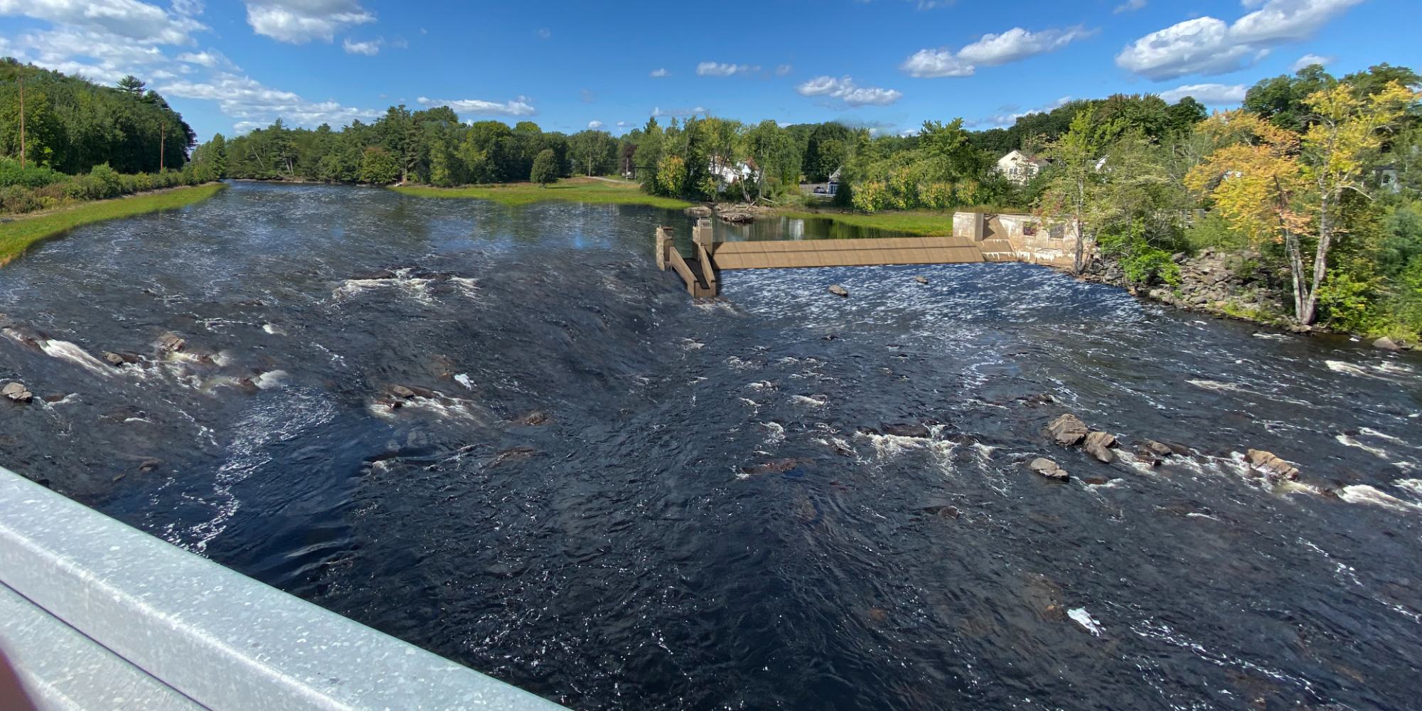
Why is Brookfield White Pine Hydro only removing part of the dam?
There are several issues associated with removal of the entire spillway including significant cost, insufficient access rights, potential disturbance and erosion of the historic mill property owned by the Town of Buxton, and no significant improvement in fish passage conditions. In addition, partial removal results in less impact during construction.
What will Brookfield White Pine Hydro do with the remaining structures?
Brookfield White Pine Hydro will retain the powerhouse to use for operational purposes, such as materials and equipment storage and office space. The gate structure at the north end of the canal will be removed and a small weir, consistent with the historic shoreline boundary, will be installed to prevent flow, debris, and fish from entering the canal under most flow conditions. The gate at the spillway section adjacent to the powerhouse will be removed to allow the canal to drain and for fish egress should it be overtopped under high flow conditions. A portion of the spillway will be retained.
Brookfield White Pine Hydro, as part of any FERC-approved decommissioning plan, will be required to maintain and upkeep these structures. The crane next to the powerhouse is a historic structure, and its fate is yet to be determined. We expect the aesthetics to be generally consistent with present views.
Will the boat ramp, angler trail, and canoe portage be accessible?
Yes, we will maintain access to these sites for the duration of the surrender application process. Decommissioning of the Project may affect the use of these sites. Should there be any changes in the interim, we will notify the public.
Will the recreation sites be removed once the decommissioning is finalized?
BWPH is committed to working with stakeholder groups and local municipalities to determine the future use of recreation amenities. Just like with other components of this process, future use of the recreation sites will be subject to FERC review and consultation with agencies and stakeholders.
What lands will be retained by Brookfield White Pine Hydro?
All Brookfield White Pine Hydro lands owned in fee and all easements will be retained. These include:
- the island located 0.6 mile upstream from the existing dam;
- Usher Island;
- the boat launch;
- the canoe portage trail;
- portions of the powerhouse access road; and
- lands on which project structures are located.
The only easements at the Bar Mills Project are the CMP reserved easements listed in the Bar_Mills-1999_Deed. There is also an access agreement with the Hollis Honkers Snowmobile Club for a trail down the Canal Road through project property which will continue.
What areas are subject to removal from the FERC Project Boundary?
The project boundary for Bar Mills goes upstream from just below the West Buxton hydro station and downstream an estimated 200 feet below the Bar Mills powerhouse. Once the surrender application has been approved by FERC, there is no longer a FERC project boundary.
What will happen to the water levels between Buxton and Bar Mills?
BWPH has undertaken assessments to evaluate how water levels will be impacted. Bar Mills is a run-of-river dam and flows are not expected to be impacted. With that said, some shoreline changes are anticipated due to changes in water levels following decommissioning. An interactive map showing these anticipated changes during a typical summer low flow period is available for review.
I am a landowner living near Bar Mills. Will the land I own be impacted?
Some shoreline changes are anticipated due to changes in water levels following decommissioning. An interactive map showing these anticipated changes during a typical summer low flow period is available for review.
How were the river boundary and elevations determined?
The existing water levels in the river upstream of Bar Mills Dam are controlled by the elevation of the dam. After removal of the dam structures, the water levels will be controlled by the natural topography of the river channel.
To estimate the future water levels of the river, post-removal, a one-dimensional hydraulic model was developed using the U.S. Army Corps of Engineers’ HEC-RAS v6.1 software, which is the industry standard modeling software to analyze rivers. This model allows for calculation of water levels for selected flow conditions. To accurately represent the natural river bottom terrain that will control future water levels, a bathymetric survey was performed to collect data along the river downstream of West Buxton Dam to the tailrace of Bar Mills Dam.
The river analysis model was run for a variety of flow conditions to estimate the water levels along the river upstream of the Bar Mills Dam site post-removal.
Based on feedback from the Public Informational meeting, Brookfield and Kleinschmidt are in the process of updating the hydraulic model from one-dimensional (1D) to two-dimensional (2D), to provide a more detailed estimate of the river width and depth along the entire reach along with a clearer graphical representation. The 2D model results will allow stakeholders to view the calculated depth of water for the existing and proposed low flow conditions anywhere in the reach between West Buxton Dam and the Bar Mills Dam. Once the 2D model is completed Brookfield will provide access to the information from a link on this website.
What happens to the river once the Bar Mills Dam is decommissioned?
River flows (i.e. the quantity of water that flows through this reach of the river) will be unchanged from current conditions. River flows are dictated by inflow into the river from natural runoff as well as releases from upstream dams. The required minimum flows from these upstream dams will not change.
Specifically, Bar Mills is an intervening dam. It is above five other dams on the lower Saco River (Skelton, Spring Island, Bradbury, East Channel, and West Channel) and below three dams on the upper Saco River (Hiram, Bonny Eagle, and West Buxton). All of the Projects are operated in accordance with the 1997_Instream_Flow_Agreement_Saco_River, and their current FERC licenses.
Flows in this reach of the river are discharged from the upstream West Buxton Project, which requires a year-round minimum flow of 768 cubic feet per second (cfs), or inflow, whichever is less. This will be unchanged with the decommissioning of Bar Mills.
The width of the river, water surface elevations, depth and velocities will change and will be more or less pronounced in select reaches, based on the natural channel characteristics. Modeling results of the water surface elevations under various flow conditions can be found here: https://experience.arcgis.com/experience/2d2366deb9e4492092eb29cb16435b29/
Given that Bar Mills has been operated in run of river mode, meaning all water is passed downstream and no storage exists at the Project, depths downstream are generally expected to be unchanged.
What is the difference between the partial breach and the full breach alternative on the river?
River flows will be unchanged from current conditions for a full or partial breach because flows are dictated by upstream projects. The depths of the currently impounded reach above Bar Mills Dam and extending to the West Buxton Dam would be effectively no different between the full removal and partial removal option, with the exception of the area immediately upstream of the spillway itself. All upstream depths are the same with either option.
Are there any risks to the safety of boaters, kayakers, etc. by leaving a portion of the spillway intact?
The risk to boaters would be similar to any structure in the river, such as bridge abutments and piers, several of which are located in close proximity to the spillway under existing conditions. Given that the majority of the flow will follow the route of the breach, and velocities will be relatively low in the vicinity of the dam under median summer recreation season flows, the existing abutment is not expected to pose a public safety concern. A similar configuration exists on the Sebasticook River, where a portion of the Fort Halifax Project structures were left in the waterway and no issues with public safety have been reported.
What has Brookfield White Pine Hydro done to avoid this outcome?
Brookfield White Pine Hydro and previous owners have undertaken numerous studies to address the alkali-aggregate reaction (AAR) issues with the powerhouse for the past 50 years. Unfortunately, the AAR has caused misalignment of the operating components of the units and there is no ability for further adjustments. The AAR has also caused binding in the gates that admit water to the turbines, limiting generation and the ability to physically stop the units.
In the event that an emergency shut down is required, the gate binding increases the risk of catastrophic mechanical and electrical damage, fire, and potentially even a structural failure, which is not acceptable for worker or public safety, and the decision was made to shut off the units in 2017. Brookfield White Pine Hydro, as well as previous owners, have investigated powerhouse repair and turbine realignment and replacement alternatives, as well as alternative fish passage mitigation options. Brookfield believes decommissioning is the best alternative given the operational, environmental, and future dam safety needs.
What is the fate of the former Roger Fibre Mill?
The Rogers Fibre Mill is a United States Environmental Protection Agency (EPA) Superfund Site located on lands owned by the Town of Buxton which are adjacent to and downstream of the Bar Mills Dam. According to the EPA, the site was “used as a manufacturing facility of the fiberboard industry from approximately 1917 to 1980 by Rogers Fibre Co…Since the facility was abandoned, unknown materials in tanks and other containers were left in the mill. The mill structure had deteriorated to the extent that portions of the mill had collapsed…In summary, the site has been used for the storage and/or disposal of wastes, including wastes containing hazardous substances. Samples taken by EPA from this waste indicated the presence of chromium.”
The EPA undertook remediation measures in the late 1990s, including an inventory, sampling and analysis of tanks, vats and/or drums stored onsite; overpacking and staging of any identified hazardous substances; demolition of the structurally unsafe contaminated building; removal of asbestos-contaminated materials; and disposal of any identified hazardous substances and contaminated materials at EPA-approved disposal facilities. By April 30, 2000, EPA had spent over $3.8 million remediating the site. More information on the Rogers Fibre Mill Superfund Site can be found here: https://cumulis.epa.gov/supercpad/CurSites/cadminrecord.cfm?id=0102964
The site of the former mill structure is located on lands owned by the Town of Buxton; is not owned nor operated nor situated on any lands owned by Brookfield White Pine Hydro; is not part of the Bar Mills Project; and is not located within the Bar Mills FERC Project Boundary. A concrete water retaining structure that previously supplied water to the mill is located immediately adjacent to the existing Bar Mills Dam spillway. In 2008, when issuing the latest license for the Bar Mills Project, FERC determined that because the concrete abutment of the former mill site is a water retaining structure integral to the spillway, it is considered a project feature and FERC requested it be included in the project boundary.
Given the potential for contaminated soils, disturbance of this site was a factor, among others, considered by Brookfield White Pine Hydro in evaluating alternatives for a full breach, wherein a full breach would very likely result in disturbance and erosion of the Rogers Fibre Mill Superfund site.
Who can I contact at Brookfield Renewable for more information?
Updates will be communicated on this website as more information becomes available. In the meantime, you can e-mail questions to maine.inquiries@brookfieldrenewable.com.
What can the stakeholder do to participate in the process?
Stakeholders are afforded several opportunities to participate in the various regulatory processes, including the FERC decommissioning plan/surrender application and state, federal and local permits, all of which include opportunities for public meetings and public comment.
Brookfield White Pine Hydro will keep the Bar Mills website updated with the latest information. A recording of the public informational meeting can be found here: https://livestream.com/accounts/23355313/events/8556209/videos/232363649 and a copy of the presentation has been uploaded to this website.
Brookfield White Pine Hydro encourages stakeholders to submit questions and concerns to barmills@kleinschmidtgroup.com and to continue to monitor the website: https://barmills.brookfieldusprojects.com/ for updates and scheduled public meetings, applications and opportunities for comment.
Where else can I learn more information about the filings associated with this project?
The Federal Energy Regulatory Commission (FERC) makes it easy for stakeholders to follow and participate in this process. Most documents can be submitted online at www.ferc.gov and are also available to read online.
If you wish to receive email notification of all filings associated with the Bar Mills Project, you can sign up using FERC’s eSubscription service, located at www.ferc.gov/docs-filing/esubscription.asp, and following the steps there for registration. You will want to subscribe to Project number P-2194.
Who can the media contact for more information?
For media questions, please contact david.heidrich@brookfieldrenewable.com.
Revision Date: 10/24/2022